
7 Joshua Tree Rock Formations You Won’t Find On The Park Map (Including Heart Rock)
Anyone who's been to Joshua Tree National Park knows that there are all sorts of rock formations throughout the park. But, did you know there are some amazing formations that aren't on the park map? Here is a list of our favorite Joshua Tree rock formations you won't find on the park map, including Heart Rock. As official WKNDR fam, you’ll get access to a google map of each of the locations at the end of this article. Happy exploring!
7. Vulture Arch

Coordinates: 33.9857, -116.0138
The little-known but very attractive Vulture Arch at Joshua Tree National Park is a great spot to capture the mid-afternoon sun with your camera. It is in shadow during the morning, so best saved for after hitting more iconic stops like Skull Rock. The span of this particular arch measures just over seven feet, which makes it perfect for those wanting something striking yet less crowded than the very popular Arch Rock. Come here to escape the crowds and take snaps at your leisure.
6. Balanced Rock aka The Marble Viewpoint
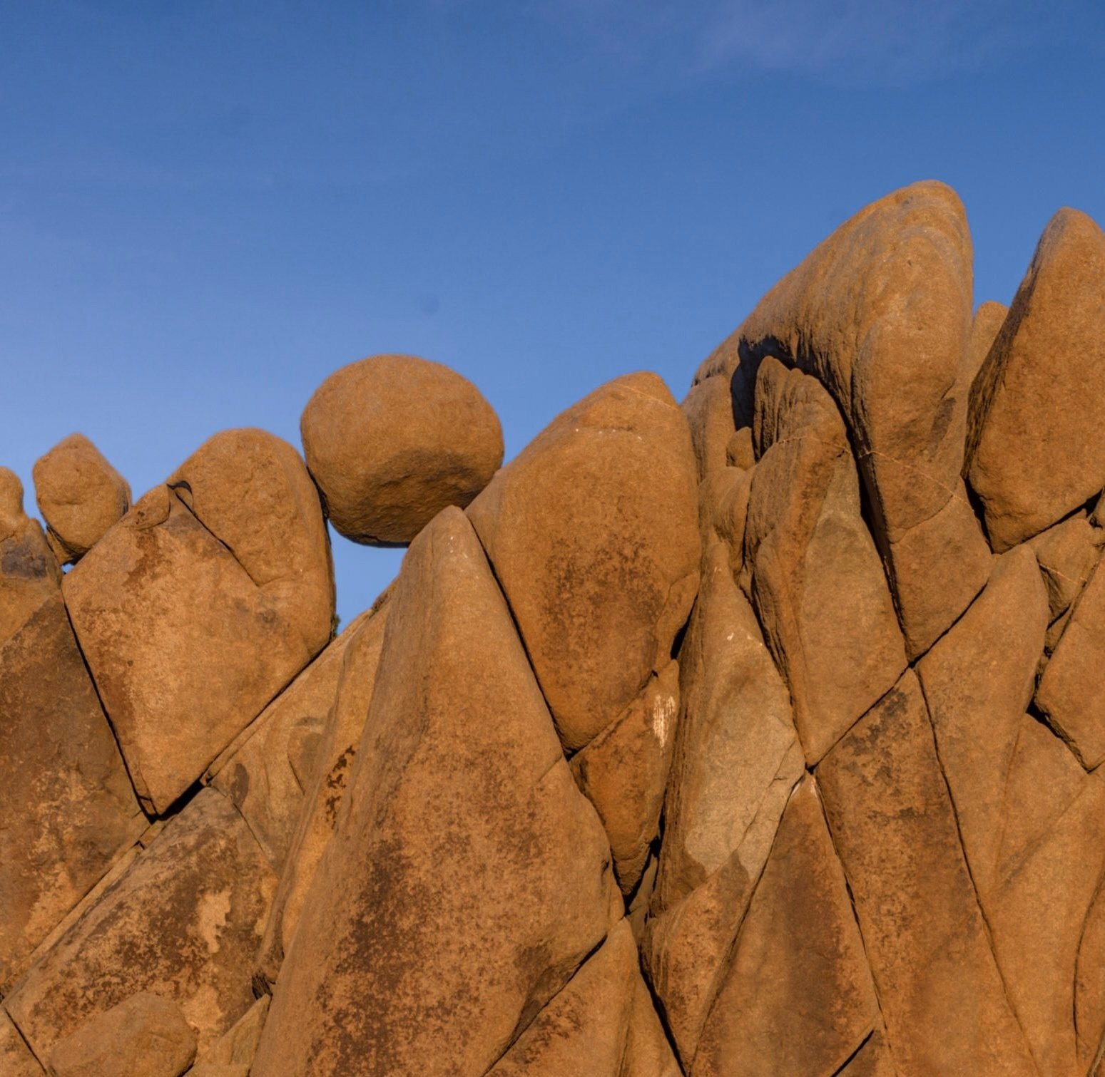
Coordinates: 33.9929, -116.0612
These almost spherical marbles are natural anchors for many famous landscape photos of this boulder group. The best time to photograph this formation is at peak lighting during mid-afternoon to sunset. It can be found by taking Skull Rock Trail. The trail ends near campsite is #93 in Jumbo Rocks Campground. They don’t allow parking inside the campground unless you are camping here, so take the trail or you may have to walk in from the campground entrance.
5. Juniper Tree & Spire Rock aka Penguin Rock
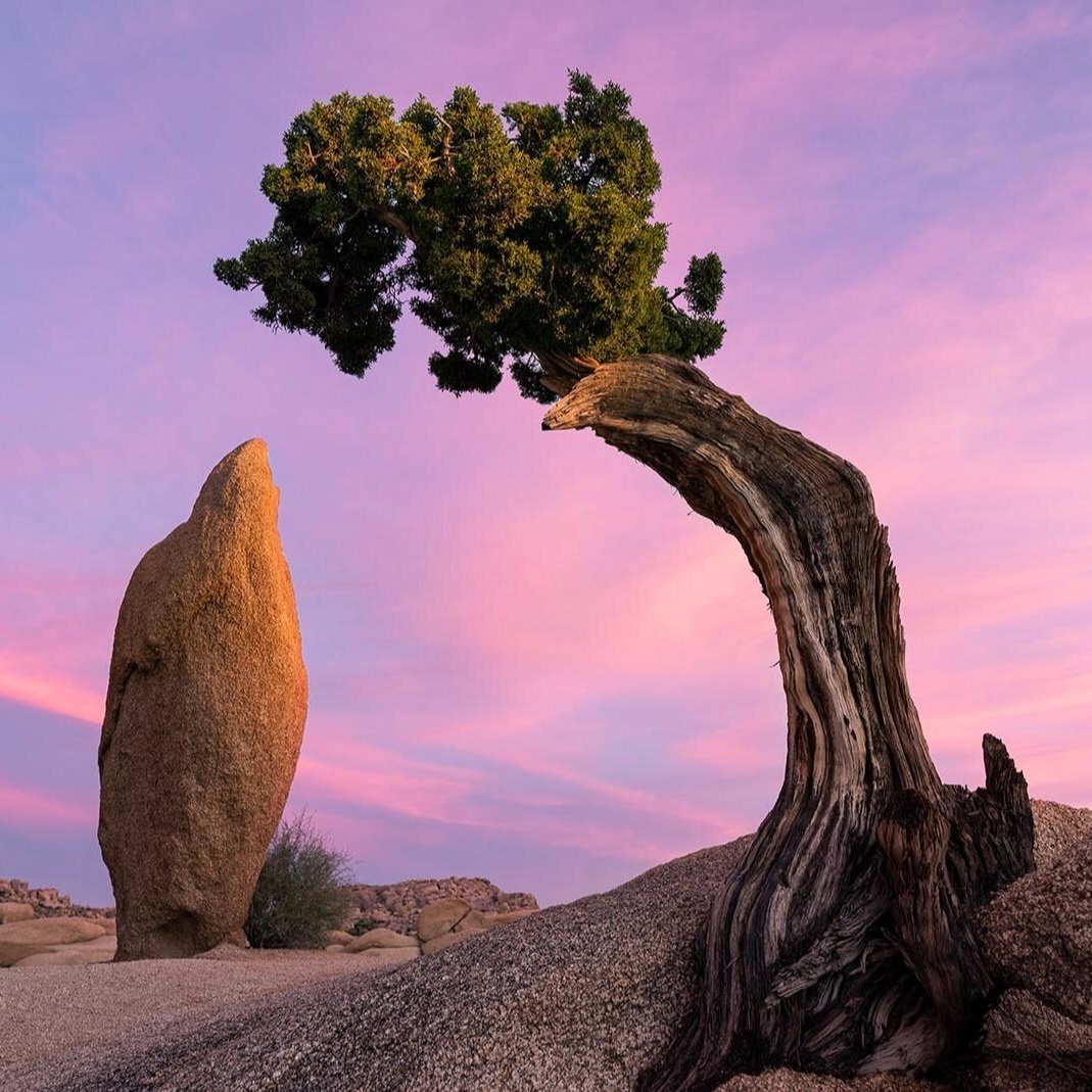
Coordinates: 33.9912, -116.0642
Just when you think that the Jumbo Rocks Campground can't get any more intriguing, a rare and beautiful penguin formation appears. This is the perfect destination for those who love taking astrophotos or milky way shots with an interesting foreground subject. Lighting is also amazing at sunset. Like the marbles, it’s located inside of the Jumbo Rocks Campground, just above campsite #18. Be considerate of the campers here if you visit, since the spot is in the bouldering area above the campsite. Access this rock formation using the notes from Balanced Rock.
4. Dragon Scales Boulder aka Illicit Sweetie Boulder

Coordinates: 33.998, -116.154
This alligator-skinned boulder is a hot spot for those just getting into bouldering. If you’re looking to give bouldering a try, enjoy taking photos of climbers in action, or want to see some crazy kids go vertical on a weird rock, we highly recommend taking this short detour from Hall of Horrors. This is also a great area to catch the sunset without huge crowds.
3. Bullseye Rock

Coordinates: 34.011390, -116.014254
Bullseye Rock is an awesome semi-secret and accessible stop at Joshua Tree National Park. This rock is a giant triangle with an 8’-circular hole drilled through the tip. It is along the California Riding and Hiking Trail in Joshua Tree National Park . You can take pictures from afar at a parking area off of Pinto Basin Road, however, we prefer the short hike and scramble to get up close. A rock up the backside will help you access the Bullseye Rock formation.
2. Heart Rock

Coordinates: 33.988067733163284, -116.01350253057163
Snap your next Instagram masterpiece or propose to your sweetie, just beware of snakes! This heart-shaped rock at Joshua Tree National park can be easily accessed from Arch Rock. Heart Rock gets its name from its very literal heart shape. There are also additional nearby hiking trails in case you want to combine an adventure with your picture-taking session. Make sure to load our google map on your phone before heading in the park to maintain the GPS coordinates when you inevitably lose service.
1. Wave Rock

Trailhead coordinates: 34.0251, -116.1419
Surf the only human-sized rock wave at Joshua Tree National Park. Likely created from a soil pocket during erosion, this wave-like rock is a great place to take photos or even stop for a shaded afternoon snack away from the crowds at Hidden Valley.
To get there, park at the closest trailhead to Wall Street Mill. After taking the trail only 1 tenth of a mile, you’ll find a junction with an unmarked track departing to the left. This trail will take you to the pink-painted crumbling ruins of Wonderland Ranch.
To the left of the ruins, pick up the path heading east through a low boulder pile into the wash. Stick to the bottom of the wash to remain on course. After a third of a mile, you’ll pass an old dam forged by cattle ranchers of the past. After only a quarter mile more, you’ll find an eye-catching rock that resembles a whale or shark. This is the wave. Climb around to the other side of the whale and the wave will reveal itself.
These Joshua Tree rock formations are just a sampling of what you can find if you explore off the beaten path in Joshua Tree National Park. Only attempt these quests if you are a seasoned hiker and comfortable going off-trail. Be sure to bring your camera and share your photos with us on Instagram or Facebook using #wkndrlife. Which rock formation is your favorite? Tell us in the comments below.